


雅思小作文地圖題真的很難嗎?事實上,這是所有 Task 1 題型中最容易掌握且最有規律可循的類型之一。相較於需要分析複雜數據趨勢的線圖或餅圖,雅思小作文地圖的核心任務僅在於準確描述空間變化與位置關係,只要掌握正確的寫作結構與詞彙運用,從 6.0 提升到 7.0 甚至更高分數並非難事。然而,許多考生在初次面對地圖題時會感到困惑,不知道該如何組織內容、選擇時態,或者擔心詞彙不足以精確表達複雜的空間關係。
這種擔憂其實源於對題型特徵的不熟悉以及缺乏系統化的應對策略。地圖題在雅思考試中出現頻率雖不如數據圖表高,但一旦遇到,它往往成為決定分數高低的關鍵。IELTSTongXue 作為專業的語言學習平台,深入研究了數百份高分範文與考官評分標準,發現地圖題的高分答案都遵循相同的黃金法則:清晰的四段式結構、精準的方位詞彙、恰當的時態運用,以及對主要特徵的準確識別。
本指南將為你提供一套完整且可執行的寫作策略,從題型識別、結構規劃、詞彙升級到實戰範文分析,幫助你系統化掌握雅思地圖題的所有核心技巧,讓你在考場上能夠自信從容地應對任何地圖類型,穩定發揮並達到目標分數。
I. 為什麼雅思小作文地圖題是你的「提分機會」而非「失分陷阱」?
許多考生在面對地圖題時會感到焦慮,但這種擔憂往往源於不熟悉,而非題目本身的難度。事實上,相較於數據密集的線圖或複雜的流程圖,地圖題具有明顯的優勢。
- 首先,地圖題需要處理的數據量少得多,你不需要分析複雜的數字趨勢或計算百分比變化。
- 其次,地圖題的描述模式高度規律化,一旦掌握核心詞彙與句型,就能反覆運用在不同題目中。
- 最後,地圖題的IELTS評分標準相對明確,只要做到結構清晰、描述準確、語言流暢,要達到 7 分以上並不困難。
理解考官如何評估你的地圖題作答,是提升分數的關鍵第一步。雅思 Writing Task 1 的評分包含四個維度,每個維度在地圖題中都有其獨特的體現方式。
| 任務完成度 | 任務完成度這個維度考查你是否全面且準確地呈現了地圖上的所有關鍵資訊。具體來說,你需要展現出敏銳的資訊篩選能力,能快速找出最重要的變化點,而不是流水帳式地列舉每個細節。你必須能夠識別出哪些變化對整體區域產生了最顯著的影響,並在概述段中清楚說明這些核心特徵。 |
| 連貫與銜接 | 連貫與銜接這個標準關注你的文章是否具有清晰的邏輯結構。在地圖題中,這意味著你需要採用合理的分段方式,例如按照地理方位劃分,或根據變化類型分類。每個段落內部的句子之間應該流暢過渡,使用恰當的連接詞來建立空間關係或時間順序。一個結構良好的回答能讓考官輕鬆理解你的描述路徑,而不會感到困惑或需要反覆閱讀。 |
| 詞彙資源 | 詞彙資源在地圖題中尤其重要,因為你需要頻繁使用方位詞、變化動詞和空間介詞。考官希望看到你能靈活運用多樣化的詞彙,避免重複使用相同的表達方式。例如,描述建築物的新增時,你可以交替使用 construct、build、erect、establish 等動詞,展現你的語言儲備深度。同時,準確使用專業術語如 residential area、commercial zone、pedestrian path 也能提升你的詞彙分數。 |
| 語法範圍與準確性 | 語法範圍與準確性要求你在描述地圖時展現多樣化的句型結構。你需要熟練掌握被動語態來描述建築物的建造,使用過去式或現在完成式來呈現已發生的變化,並在描述未來規劃時正確運用 will be 或 is planned to be 等結構。複雜句的使用,如包含關係從句或分詞結構的句子,能有效提升你的語法分數,但前提是必須保持準確性,避免出現明顯的文法錯誤。 |
看更多文章:
II. 秒速識別三大核心雅思小作文地圖題型與應對策略
掌握地圖題的第一步是能夠快速識別題型,因為不同類型的地圖需要採用不同的時態、詞彙和描述策略。IELTS Writing Task 1 Map 主要分為三大核心類型,每種類型都有其獨特的特徵與應對方法。理解這些差異能讓你在考場上迅速制定寫作計畫,避免浪費寶貴的思考時間。
1. 類型一: 古今變遷圖 (Past vs. Present)
古今變遷圖是雅思小作文地圖中最常見的類型,通常呈現同一地點在兩個不同時間點的面貌,例如 1995 年與現在,或者 1950 年代與 2020 年代。這種題型的核心任務是比較兩個時期的差異,找出在這段時間內發生的所有重要變化。
- 審題關鍵在於立即確認兩張地圖代表的確切年份,這將決定你使用的時態。仔細觀察圖例說明,了解不同顏色或符號代表的設施類型。將兩張地圖進行對照,就像玩「找不同」遊戲一樣,標記出消失的建築、新增的設施、擴建的區域以及功能轉變的地點。
- 策略核心是採用過去式與現在完成式的組合。例如,你可以說「The farmland in the eastern part was converted into a residential area」來描述土地用途的改變,或使用「A shopping mall has been constructed on the site of the former car park」來強調過去的行為對現在的影響。在組織內容時,建議按照變化的類型或地理方位進行分組,而不是毫無章法地羅列所有差異。概述段應該清楚點出整體變化的性質,例如區域是否變得更加都市化、商業化或工業化。
這類題型最容易犯的錯誤是使用錯誤的時態,或者過於關注細節而忽略了整體趨勢。記住,你的目標不是描述每一個微小的變化,而是呈現最顯著、最有意義的轉變。
2. 類型二: 單一地點佈局圖 (Single Map Description)
單一地點佈局圖只提供一張地圖,要求你描述某個特定場所的空間配置,例如圖書館的平面圖、校園的設施分布或公園的區域劃分。這種題型沒有時間維度的比較,重點在於清晰準確地呈現各個設施的位置關係。
- 審題關鍵是建立清晰的方位感。你需要在地圖上找到一個明顯的參照點,例如主要入口、中央廣場或主幹道,然後以此為基準來描述其他設施的位置。注意觀察地圖上是否標示了東南西北等方位,或者是否有明確的「top」、「bottom」等指示。
- 策略核心是運用豐富的空間介詞和方位詞。你需要能夠精確表達「A is located to the north of B」、「C is situated in the central part of the area」、「D is adjacent to E」等空間關係。描述路徑時,可以採用「順時針」或「由外而內」的描述順序,確保邏輯連貫。由於這類題型沒有時間變化,你應該使用一般現在式,並專注於位置描述的準確性。
在組織內容時,可以按照功能區域分段,例如第一個主體段描述教學設施的分布,第二個主體段描述休閒與服務設施的位置。或者,你也可以採用地理分區法,依次描述北部區域、南部區域、東部區域和西部區域的配置情況。
3. 類型三: 未來規劃藍圖 (Present vs. Future)
未來規劃藍圖呈現現狀與計畫中的未來發展藍圖的對比,地圖上通常會用虛線、不同顏色或「proposed」等標示來區分現有設施與規劃中的建設。這種題型在時態運用上具有獨特性,需要你熟練掌握未來式的各種表達方式。
- 審題關鍵在於區分哪些是現有的設施,哪些是計畫中的變更。仔細閱讀圖例,確保你正確理解「planned」、「proposed」、「to be built」等標示的含義。注意觀察規劃中的變化是新增、拆除、擴建還是功能轉換。
- 策略核心是正確運用未來時態和被動語態的組合。描述現狀時使用一般現在式,例如「Currently, there is a small park in the city centre」。描述未來規劃時,則需要使用「will be + 過去分詞」或「is/are planned to be + 過去分詞」的結構,例如「A new shopping complex will be constructed in the western part」或「The existing car park is planned to be replaced by a multi-storey residential building」。
這類題型的概述段應該明確指出整體規劃的方向與目標,例如「The development plan aims to transform the area into a more residential-focused zone」或「The proposed changes will significantly enhance the commercial facilities in the region」。在主體段中,你可以先描述將被保留的設施,再詳細說明計畫中的新建與改造項目,這樣的安排能讓對比更加清晰。
III. 不可撼動的黃金四段式高分雅思小作文地圖結構
無論面對哪種類型的地圖題,採用標準的四段式結構都是獲得高分的基礎。這個結構經過無數高分考生的驗證,能夠確保你的回答具備清晰的邏輯框架,同時滿足考官對任務完成度與連貫性的要求。四段式結構包括引言、概述和兩個主體段,每個部分都有其特定的功能與寫作要點。
1. 第一段 (Introduction)
引言段的主要功能是改寫題目,向考官展示你理解了任務要求。這一段不需要包含任何具體的地圖細節,只需要用你自己的語言重新表述題目中的資訊即可。一個好的引言段通常包含地圖的主題、時間範圍和比較的性質。
改寫技巧的核心在於替換關鍵詞彙和改變句子結構。如果題目說「The maps show the changes in a town」,你可以改寫為「The two maps illustrate the transformation that took place in a town」或「The diagrams compare how a town evolved」。將「show」替換為「illustrate」、「depict」、「present」或「compare」,將「changes」替換為「transformation」、「development」、「evolution」或「modifications」。你可以使用以下模板句型來建構你的引言段:
- The two maps illustrate the changes that took place at [地點] between [年份] and [年份].
- The diagrams compare the layout of [地點] as it was in [年份] and as it is now.
- The maps depict how [地點] has been transformed over a period of [時間長度] from [年份] to [年份].
記住,引言段應該簡潔明瞭,通常一到兩句話就足夠了。不要在這個段落中加入任何主觀評論或具體的變化描述,那些內容應該留到後面的段落中展開。
2. 第二段 (Overview)
概述段是整篇文章最重要的部分,決定了你能否在任務完成度這個維度獲得高分。這一段的目的是總結地圖上最顯著、最關鍵的特徵,讓考官在閱讀細節之前就能掌握整體變化的概況。一個優秀的概述段應該包含兩到三個主要觀察結果,這些結果必須是宏觀層面的描述,而不是具體的細節。
如何識別值得寫入概述段的關鍵特徵呢? 你可以問自己以下幾個問題: 整體區域的主要功能是否發生了根本性改變? 例如從農業區轉變為住宅區,或從工業區轉變為商業區。新增或拆除的設施中,哪些對區域性質產生了最大影響?例如建造了大型購物中心、拆除了工廠,或新增了交通樞紐。區域的整體密度是否有明顯變化?例如建築物變得更密集,或綠地面積大幅減少。哪些類型的設施數量增加或減少最顯著?例如住宅數量大幅增加,或娛樂設施顯著擴充。你可以使用以下表達方式來構建概述段:
- Overall, the area underwent significant transformation, with the most noticeable change being…
- In general, the region became more urbanised/commercialised/residential, as evidenced by…
- The most striking feature is that the number of [設施類型] increased substantially, while…
- It is clear that the area experienced considerable development, particularly in terms of…
概述段的語言應該保持相對抽象和概括,避免提及具體的建築名稱或精確的位置描述。例如,不要說「A hospital was built next to the library」,而應該說「Healthcare facilities were introduced to the area」。這樣的表達方式既準確又具有總結性,符合概述段的功能定位。
3. 第三、四段 (Body Paragraphs)
主體段是你展開具體描述的空間,需要將地圖上的所有重要細節有條理地呈現出來。這兩個段落的組織方式有兩種主流策略,你需要根據具體的地圖特徵來選擇最適合的方法。
- 方位分段法是最直觀的組織方式,特別適合變化分散在地圖不同區域的情況。你可以將地圖劃分為北部與南部、東部與西部,或者採用東北、東南、西北、西南的四分法。例如,第一個主體段描述地圖北半部的所有變化,包括新增的設施、拆除的建築和擴建的區域。第二個主體段則描述南半部的情況,採用相同的描述邏輯。這種方法的優點是讓讀者能夠清晰地跟隨你的描述路徑,在腦海中重建地圖的面貌。
- 變化類型分段法則適合變化集中且具有明確類別的情況。你可以將變化分為「新增與擴建」以及「拆除與縮減」兩大類,或者按照「住宅發展」、「商業建設」、「交通改善」等功能類別分段。例如,第一個主體段集中描述所有新增的建築和設施,包括新建的住宅區、購物中心和道路。第二個主體段則專注於被拆除的舊建築、縮減的綠地以及功能轉變的區域。這種方法能夠讓你的描述更具主題性,便於運用相關的詞彙群組。
讓IELTSTongXue用一個具體例子來展示這兩種方法的實際應用。假設地圖顯示一個小鎮從 1990 年到現在的變化,北部新建了一個住宅區和學校,南部的農田被改造為工業園區,東部新增了一條高速公路,西部的小型商店被大型購物中心取代。
- 採用方位分段法時,你的第一個主體段可能這樣寫:「In the northern part of the town, a residential area was constructed where farmland previously existed, accommodating approximately 200 houses. Adjacent to this residential zone, a primary school was established to serve the growing population. Moving to the eastern section, a major highway was built to improve connectivity with neighbouring regions.」第二個主體段則描述南部和西部的變化。
- 採用變化類型分段法時,你的第一個主體段可能聚焦於新增設施:「Several new facilities were introduced to enhance the town’s infrastructure. A residential area consisting of 200 houses was developed in the northern part, supported by a newly built primary school. Additionally, a highway was constructed in the east to facilitate transportation.」第二個主體段則描述功能轉變與取代:「Regarding functional changes, the farmland in the southern part was transformed into an industrial park, marking a shift from agricultural to manufacturing activities. Furthermore, the small shops in the western area were replaced by a large shopping mall, reflecting the commercialisation trend.」
兩種方法各有優勢,關鍵是選擇能讓你的描述最清晰、最有邏輯性的那一種。無論採用哪種方法,都要確保每個段落內部使用恰當的連接詞來建立句子之間的關聯,並在段落之間使用過渡句來保持整體的流暢性。
看更多文章:
- 雅思小作文線圖:高分結構與詞彙策略解析
- 雅思小作文柱狀圖終極指南:結構+詞彙+範文全解析
- 雅思小作文餅圖終極指南:從零到滿分的實戰秘訣
- 雅思小作文表格高分秘訣:20分鐘內寫出7分作文的方法
- 雅思小作文流程圖終極指南:詞彙、範文、高分策略
IV. 詞彙升級:從精準到驚艷的高分詞彙與句型庫
IELTS詞彙的豐富性與準確性是區分高分與低分回答的關鍵因素之一。在雅思地圖題中,你需要掌握三大類詞彙:方位與定位詞彙、描述變化的動詞,以及連接詞與過渡短語。以下的詞彙庫將為你提供系統化的語言素材,幫助你在考試中自如地表達各種空間關係與變化類型。
1. 方位與定位
準確表達位置關係是地圖題寫作的基本功。除了基礎的東南西北四個方位,你還需要掌握更精確的空間介詞和關係詞彙,才能清楚描述設施之間的相對位置。
| 功能類別 | 雅思小作文地圖核心詞彙 | 高分例句 |
| 基本方位 | north/ south/ east/ west
northern/ southern/ eastern/ western |
The shopping centre is located in the northern part of the town, while the residential area occupies the southern section.(購物中心位於鎮上的北部,而住宅區則佔據了南部地區。) |
| 相對位置 | adjacent to
next to beside alongside |
A new library was constructed adjacent to the existing community centre, providing convenient access for residents.(新圖書館建在現有的社區中心旁邊,為居民提供了便利的通行。) |
| 中心與邊緣 | in the centre of
in the middle of at the heart of on the outskirts of on the periphery of |
The town hall stands at the heart of the commercial district, whereas the industrial facilities are situated on the outskirts of the area.(市政廳位於商業區的中心,而工業設施則坐落在該地區的邊緣。) |
| 對面與之間 | opposite
across from facing between…and… |
The hospital is located opposite the main park, and a pedestrian bridge was built between the two facilities.(醫院位於主要公園的對面,兩個設施之間建有一座人行天橋。) |
| 角落與沿線 | in the corner of
along running through |
Several cafés were established in the northeast corner of the square, and a cycle path was created along the riverbank.(幾間咖啡館設立在廣場的東北角,沿著河岸建了一條自行車道。) |
使用這些詞彙時,要注意介詞的準確搭配。例如,「in the north」表示在某個範圍的北部區域內,而「to the north of」則表示在某物的北方位置,兩者含義略有差異。掌握這些細微區別能讓你的描述更加精確,避免產生歧義。
2. 描述變化
變化描述是地圖題的核心內容,你需要能夠準確表達各種類型的改變,包括新增、拆除、擴建、縮減和功能轉換。以下表格按照變化類型進行分類,提供多樣化的動詞選擇。
| 功能類別 | 雅思小作文地圖核心詞彙 | 高分例句 |
| 新增建造 | construct, build, erect, establish, develop, create, introduce, add | A sports complex was constructed on the former industrial site, and several shops were established along the newly developed pedestrian street.(一座體育綜合設施建於原來的工業用地上,並且沿著新開發的人行街道設立了幾家商店。) |
| 拆除移除 | demolish, knock down, pull down, remove, clear, eliminate | The old warehouses were demolished to make way for residential development, and the small car park was removed to create green space.(舊倉庫被拆除以便進行住宅開發,而小型停車場則被清除來建造綠地。) |
| 改造轉換 | convert, transform, turn into, change into, replace, renovate, redevelop | The farmland was converted into a golf course, and the disused railway station was transformed into a museum.(農地被改建為高爾夫球場,而廢棄的火車站被改造成博物館。) |
| 擴大增加 | expand, extend, enlarge, widen, increase in size, grow | The university campus was expanded to accommodate more students, and the main road was widened to reduce traffic congestion.(大學校園被擴建以容納更多學生,並且主要道路被拓寬以減少交通擁堵。) |
| 縮減保留 | reduce, decrease, shrink, remain unchanged, stay the same, be preserved, be retained | The green area was reduced significantly due to urban development, while the historic town hall remained unchanged throughout the period.(由於城市發展,綠地面積大幅減少,而歷史悠久的市政廳在整個期間保持不變。) |
在使用這些動詞時,要注意被動語態的正確構造。地圖題中大部分變化描述都應該使用被動語態,因為重點是變化本身,而不是執行變化的人。例如,「A hospital was built」比「They built a hospital」更符合學術寫作的客觀性要求。同時,要避免過度重複同一個動詞,盡量在文章中交替使用同義詞,展現你的詞彙廣度。
3. 連接詞與過渡句
流暢的連接是確保文章連貫性的關鍵。除了常見的 and、but、however 等基礎連接詞,你還需要掌握更多樣化的過渡表達,特別是那些能夠建立空間關係和順序邏輯的短語。
- 段落內部的連接詞能幫助你在描述同一區域的多個變化時保持邏輯清晰。你可以使用「In addition」或「Furthermore」來添加額外的資訊,例如「In addition to the new shopping mall, a cinema complex was also introduced in the eastern part」。當你需要引入對比時,可以使用「In contrast」、「On the other hand」或「Meanwhile」,例如「In contrast to the northern area, which became more residential, the southern part underwent significant commercialisation」。
- 段落之間的過渡句則需要更明確地指出你的描述焦點轉移。你可以使用「Moving to the southern part of the town」、「Turning to the changes in the eastern section」或「With regard to the western area」來引導讀者的注意力。如果你採用變化類型分段法,則可以使用「In terms of newly constructed facilities」或「Regarding the demolition and removal」等表達來標示主題轉換。
- 時間順序的連接詞在古今變遷圖中特別重要。你可以使用「Initially」、「Originally」來描述過去的狀態,用「Subsequently」、「Later」、「Over the period」來表示時間的推移,用「By the end of the period」、「As of now」來表示最終的結果。這些時間標記能幫助讀者清楚地追蹤變化的發展脈絡。
V. 雅思小作文地圖範文 7.0+
理論知識的學習必須結合實際範例才能真正內化。以下提供五個不同類型的 IELTS Writing Task 1 Map sample, 每個範文都達到 IELTS 7.0 以上的水準,展示如何將前面所學的結構、詞彙和策略應用到實際寫作中。仔細研讀這些範文,注意它們如何組織內容、運用詞彙以及建立段落之間的連貫性。
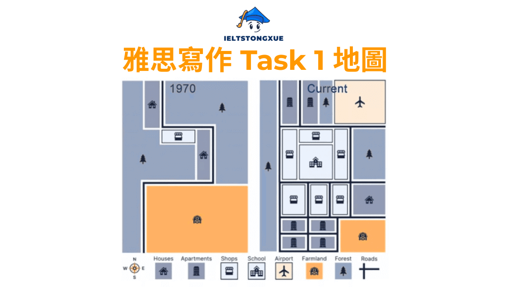
1. 雅思小作文地圖: Springer maps
題目: The following maps show the changes in the town of Springer from 1970 until now. Summarize the information by selecting and reporting the main features, and make comparisons where relevant.
雅思小作文地圖範文:
The two maps illustrate how the town of Springer transformed between 1970 and the present day, revealing substantial urban development over this period.
Overall, Springer has evolved from a predominantly rural area into a well-developed residential town, with the most striking change being the conversion of farmland into housing estates and the introduction of various community facilities including educational and transportation infrastructure.
In 1970, the town featured extensive green spaces occupying most of the area, with only a small number of houses scattered in the northern section and a single apartment building positioned along the western edge. A school was located in the southeastern corner, and the overall character remained distinctly agricultural and undeveloped.
By the current period, however, the landscape has been dramatically altered. The farmland that previously dominated the central and southern regions has been completely replaced by dense residential development, consisting of numerous houses and apartment blocks. Furthermore, several shops have been established in the central area to serve the expanding population. The most notable addition is an airport constructed in the northeastern corner, where forest previously existed. The road network has also been significantly expanded, with additional routes connecting the various residential zones and facilitating access to the new airport facility.
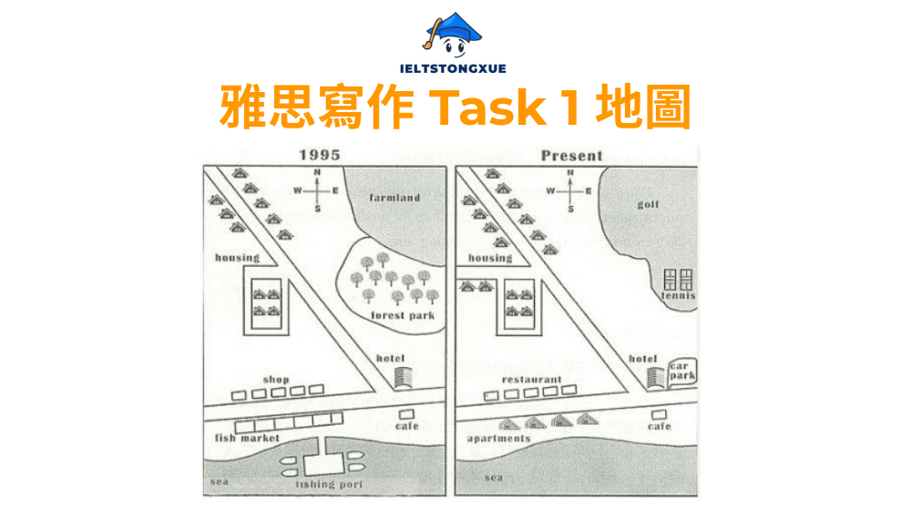
2. 雅思小作文地圖: The village of Ryemouth between 1995 and present
題目: The maps show the changes of a small village from 1995 to present. Summarise the information by selecting and reporting the main features, and make comparisons where relevant.
雅思小作文地圖範文:
The maps compare the layout of Ryemouth village in 1995 with its current configuration, demonstrating how this coastal settlement has developed over the past two decades.
In general, Ryemouth has undergone considerable transformation, shifting from a traditional fishing village towards a tourism-oriented community, with significant expansion in residential accommodation and leisure facilities, while several original features have been removed or substantially modified.
In 1995, the northern part of the village was characterized by housing areas on the western side and extensive farmland covering the eastern section. A forest park occupied a large portion of the northwestern territory, and the coastal area featured a fishing port with associated boat facilities. The southern section contained a hotel, several shops arranged in a row, a fish market positioned along the seafront, and a café situated near the intersection of the main roads.
The current map reveals substantial redevelopment throughout the village. The farmland in the eastern area has been transformed into a golf course, reflecting a shift towards recreational land use. The fishing port has been entirely removed, replaced by a series of apartments extending along the coastline. Additionally, the fish market has been demolished, and the space has been converted into a restaurant accompanied by a car park. Meanwhile, the forest park has been reduced in size to accommodate new housing developments, though the café and hotel remain in their original locations. The road connecting these facilities has been extended to serve the expanded residential areas.
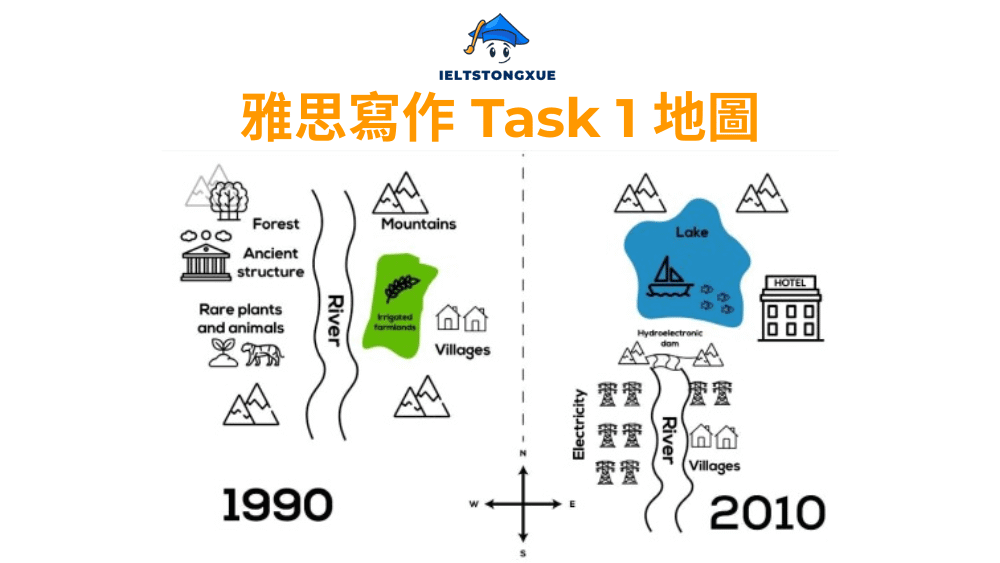
3. 雅思小作文地圖: The changes in a town after the construction of a hydroelectric power dam
題目: The maps below show the changes in a town after the construction of a hydroelectric power dam. Summarize the information by selecting and reporting the main features and make comparisons where relevant.
雅思小作文地圖範文:
The maps illustrate the transformation of a town following the construction of a hydroelectric power dam, comparing the landscape in 1990 with its appearance in 2010.
Overall, the construction of the dam resulted in the creation of an extensive lake that submerged significant portions of the original landscape, necessitating the relocation of villages and ancient structures to higher ground, while the area’s character shifted from a river valley ecosystem to a reservoir-based environment.
In 1990, the area featured a river flowing through a valley surrounded by mountains. On the western bank, a village comprising several small houses was situated alongside the river, while the eastern side contained ancient structures of historical importance. The region also supported rare plants and animals, and a forested area existed in the northwestern section. The river followed a natural course through the valley, creating a traditional rural landscape.
By 2010, the construction of a hydroelectric dam at the southern end had transformed the river into a large lake, dramatically altering the terrain. The original village on the western side was relocated to higher ground further west to avoid flooding, with new housing constructed to accommodate the displaced residents. Similarly, the ancient structures previously positioned along the eastern riverbank were moved to an elevated location and reconstructed to preserve their cultural significance. The rare plants and animals were relocated to protected areas surrounding the new reservoir. Additionally, a hotel was built near the dam to serve tourists attracted by the scenic lake views, representing a shift towards tourism-based economic activity in the region.
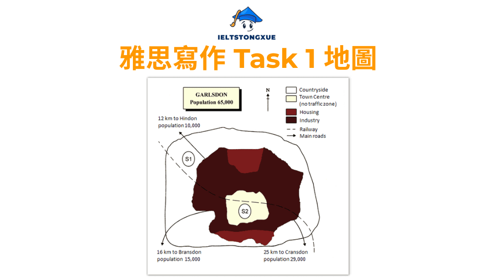
4. 雅思小作文地圖: The town of Garlsdon with a planned supermarket
題目: The map below is of the town of Garlsdon. A new supermarket (S) is planned for the town. The map shows two possible sites for the supermarket.
雅思小作文地圖範文:
The map presents the town of Garlsdon along with three potential locations for a proposed supermarket development, labelled as S1, S2, and S3.
Overall, Garlsdon is a moderately sized town with a population of 65,000, surrounded by three smaller neighbouring towns, and the three proposed supermarket sites differ significantly in their accessibility, proximity to residential areas, and potential to serve customers from multiple communities.
Site S1 is positioned in the countryside northwest of Garlsdon, approximately 12 kilometres from Hindon, which has a population of 10,000. This location lies outside the main town boundary and is situated in an area with no traffic restrictions, adjacent to the railway line. However, its distance from the town centre means it would primarily attract customers travelling by car or train rather than local residents walking from nearby housing areas.
In contrast, Site S2 is located in the heart of Garlsdon’s town centre, directly within the main residential and commercial zone where most of the population resides. This central position offers excellent accessibility for local residents but is situated within a traffic-free zone, which might create challenges for deliveries and customer parking. Site S3, meanwhile, occupies an intermediate position in the southeastern part of town, positioned between Garlsdon and the railway line. This site lies approximately 16 kilometres from Bransdon, a town with 15,000 residents to the southwest, and 25 kilometres from Cransdon, which has 29,000 inhabitants to the southeast. Its location near both the railway and the main roads connecting these towns suggests it could effectively serve customers from multiple communities while maintaining reasonable access for Garlsdon residents.
5. 雅思小作文地圖: A bookstore in 2000 and now
題目: The plans below show a bookstore in 2000 and the bookstore now. Summarise the information by selecting and reporting the main features, and make comparisons where relevant. Write at least 150 words.
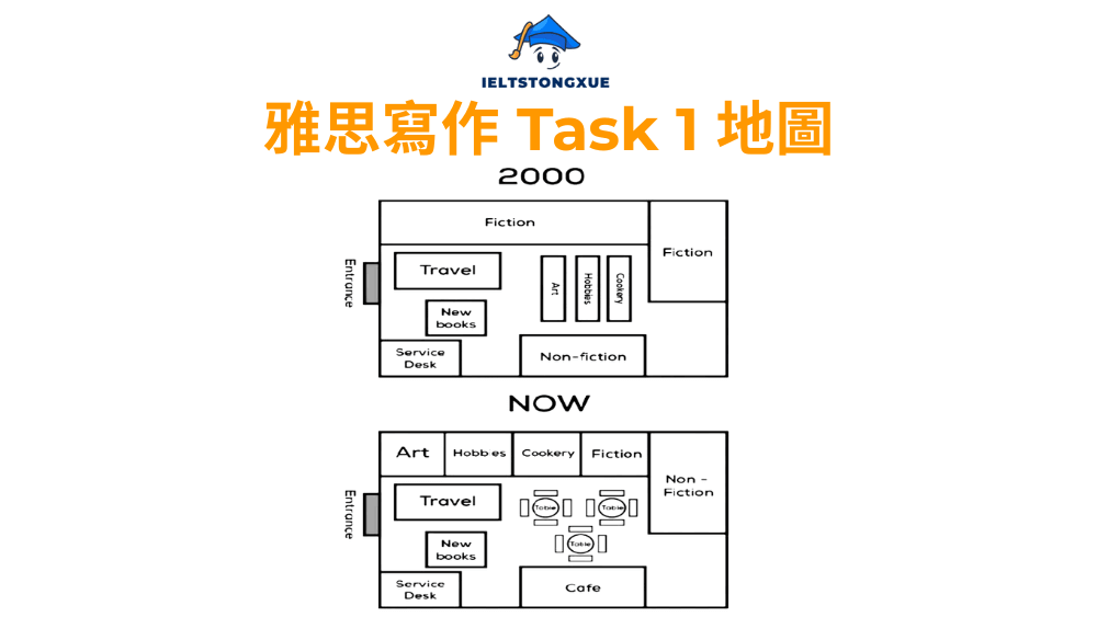
雅思小作文地圖範文:
The floor plans compare the internal layout of a bookstore in 2000 with its current arrangement, revealing how the retail space has been reorganised to adapt to changing consumer preferences and market conditions.
Overall, the bookstore has undergone a fundamental transformation from a traditional book-focused retail environment to a multifunctional space that combines book sales with hospitality services, reflecting broader shifts in the publishing industry and consumer behaviour patterns.
In 2000, the store’s layout prioritized book displays across various categories. The fiction section occupied substantial space along both the left wall and the right wall, while non-fiction held a prominent central position. Travel books and new releases were positioned in the rear left area, with a service desk situated in the lower left section to assist customers. Art and cookery books occupied smaller dedicated spaces in the upper right corner. This arrangement maximized the floor area available for book merchandising and created clear pathways for customers to browse different categories.
The current layout demonstrates a significant shift in the store’s operational strategy. The fiction section has been dramatically reduced and relocated to the right side, while non-fiction has moved to the upper right corner and also decreased in size. The most substantial change involves the introduction of a café occupying the central area where non-fiction previously stood. This café features multiple tables and seating arrangements, encouraging customers to spend extended periods in the store. Additionally, the art section has expanded and moved to the upper left area, while new categories including hobbies and cookery have been introduced along the top wall. The travel and new books sections remain in similar positions, though slightly adjusted. The service desk continues to occupy the lower left corner, maintaining its role as the primary point for customer transactions and inquiries.
VI. 雅思小作文地圖常見問題
在掌握了基本寫作策略與詞彙運用後,許多考生仍然會在實際寫作中遇到一些深層次的疑問。這些問題往往涉及評分標準的細微解讀、寫作選擇的判斷依據,以及語言運用的精確性要求。以下四個問題代表了考生在進階階段最常面臨的困惑,了解這些答案將幫助你對雅思小作文地圖的理解更上一層樓,避免那些可能影響分數的潛在陷阱。
1. 地圖題的描述中,是否「絕對」不可以加入任何圖上未標明的個人推論(例如:因為要發展觀光,所以興建了飯店)?
答案是肯定的,你絕對不應該在 Task 1 的地圖描述中加入任何主觀推論或因果分析。雅思 Task 1 評估的是你的客觀描述能力和資訊呈現能力,而非批判性思考或推理能力,那是 Task 2 議論文的考查重點。你的任務僅限於準確報告地圖上清晰可見的資訊,包括設施的位置、變化的類型以及空間關係。
考官希望看到的是純粹的事實陳述,例如「A hotel was constructed near the beach」,而不是加上推測性的解釋,如「A hotel was constructed near the beach to attract tourists and boost the local economy」。後者雖然從邏輯上可能合理,但它引入了地圖上並未明確顯示的資訊,這會被視為超出任務範圍,可能影響你的任務完成度分數。
唯一的例外是當題目本身或地圖的圖例明確提供了這些資訊時。例如,如果地圖註明「New residential area for relocating displaced residents」,那麼你可以在描述中提及這個搬遷目的。但如果地圖僅顯示「New residential area」,你就不應該自行推測建造的原因。保持客觀和忠實於視覺資訊是獲得高分的關鍵原則。
2. 在考官眼中,何謂真正值得寫入「概述段」的「主要特徵」(Key Features)?
主要特徵是指那些對整體區域產生最顯著影響、最能代表變化本質的宏觀觀察結果。考官期待在概述段中看到的不是具體的細節描述,而是能夠概括整體趨勢或核心轉變的總結性陳述。判斷一個特徵是否「主要」,可以從以下三個維度來考量。
首先,影響範圍的廣度。如果某個變化影響了地圖上大片區域或多個設施,它就值得在概述中提及。例如,「The area became significantly more urbanised」這樣的陳述概括了多個具體變化的整體效果,比單獨提及「A shop was built」更具總結性。其次,功能性質的根本轉變。如果整個區域或某個重要區塊的主要用途發生了改變,例如從農業區轉變為工業區,或從住宅區轉變為商業區,這種功能轉變就是主要特徵。最後,數量的顯著增減。如果某類設施的數量出現了明顯的增加或減少,例如住宅建築從 10 棟增加到 50 棟,或工廠從 5 座減少到 0 座,這種量變也構成主要特徵。
一個有效的概述段通常包含兩到三個這樣的主要特徵。例如:「Overall, the town underwent substantial transformation from an agricultural community to a residential suburb, with the most noticeable changes being the replacement of farmland by housing estates and the introduction of commercial facilities to serve the growing population.」這個概述涵蓋了功能轉變、主要變化類型和背後的發展邏輯,而不涉及任何具體的建築名稱或精確位置。
3. 除了建築物的增減,雅思地圖題還會出現哪些「隱性」的變化類型需要注意(例如:道路的延伸、綠地的縮減、區域功能的轉變)?
許多考生在分析地圖時,會過度關注明顯的建築物變化,而忽略了其他同樣重要的隱性變化。這些變化雖然不如新建築那麼顯眼,但對於全面完成任務同樣關鍵。以下是幾類常見但容易被忽視的變化類型。
- 交通基礎設施的變化是最常出現的隱性變化之一。這包括道路的拓寬或延伸,例如原本單線道變成雙線道,或主幹道延伸到新開發區域。橋樑、隧道、環島和停車場的新增或移除也屬於此類。此外,人行步道、自行車道或公共交通站點的設置,都是值得描述的基礎設施變化。不要僅僅說「A road was built」,而應該更精確地表達,例如「The main road was widened to accommodate increased traffic」或「A pedestrian bridge was constructed to connect the residential area with the shopping district」。
- 自然環境與綠地的變化也經常出現在地圖題中。樹木的移除或新種植、公園面積的擴大或縮減、河流的改道或水域的填充,這些都是重要的環境變化。例如,如果地圖顯示原本大片的森林被縮減為小型公園,你應該描述為「The forested area was significantly reduced in size and converted into a smaller public park」。同樣,如果農田被改造為高爾夫球場,這不僅是土地用途的改變,也反映了綠地性質的轉變。
- 區域功能的深層轉變往往比單一建築的變化更具意義。例如,一個區域從工業用地轉變為住宅用地,或從商業區轉變為文教區,這種功能定位的改變應該在你的描述中得到體現。你可以說「The southern part of the town underwent a functional transformation from industrial to residential use, as factories were replaced by apartment buildings」。這種表達方式不僅描述了具體變化,還點出了變化的本質。
- 邊界與分區的調整也是需要注意的細節。有些地圖會顯示區域界線的改變,例如住宅區與商業區之間的分界線移動,或新的土地分區被劃定。雖然這些變化不涉及具體建築,但它們反映了規劃理念的調整,值得在描述中提及。
4. 「古今變遷圖」與「未來規劃圖」在動詞時態的選擇上有何根本性的不同與相似之處?
時態的正確運用是地圖題寫作中最容易出錯的環節之一,而不同題型對時態的要求確實存在重要差異。理解這些差異和相似之處,能幫助你在考試中迅速做出正確的語言選擇。
| 段落類型 | 古今變遷圖 (Past vs. Present) | 未來規劃圖 (Present vs. Future) |
| 引言段 | 過去式與現在完成式: “The maps show the changes that took place…” | 一般現在式與未來式: “The maps illustrate how the area is planned to develop…” |
| 概述段 | 現在完成式為主: “The area has undergone significant transformation…” | 未來式為主: “The area will experience substantial development…” |
| 主體段 – 描述舊狀態 | 一般過去式: “In 1990, there was a farm…” | 一般現在式: “Currently, there is a small park…” |
| 主體段 – 描述變化 | 過去式與現在完成式: “The farm was converted into…/ has been replaced by…” | 未來式與被動: “The park will be replaced by…/ is planned to be transformed into…” |
古今變遷圖的核心時態是過去式和現在完成式。當你描述過去存在的設施時,使用一般過去式,例如「In 1995, there were several farms in the northern area」。當你描述從過去到現在發生的變化時,可以使用簡單過去式「The farms were converted into residential buildings」或現在完成式「The farms have been converted into residential buildings」。現在完成式強調變化的結果對現在的影響,而簡單過去式則單純陳述過去的事實,兩者在地圖題中都是可接受的,但現在完成式能更好地體現時間跨度的連續性。
未來規劃圖則需要運用未來時態和計畫性表達。描述現狀時使用一般現在式,例如「There is currently a car park in the centre」。描述計畫中的變化時,你有幾種選擇:簡單未來式「A shopping mall will be built」、計畫性被動「The car park is planned to be replaced by a shopping mall」,或未來完成式「By 2030, the redevelopment will have been completed」。這些表達方式都能準確傳達未來計畫的含義,選擇哪一種取決於你想強調的重點是動作本身還是規劃的性質。
兩種題型的相似之處在於,它們都需要在引言段清楚說明時間範圍,在概述段提供整體性的時間總結,並在主體段中保持時態的一致性與準確性。無論哪種題型,混淆時態都會被視為語法錯誤,影響你的文法範圍與準確性分數。因此,在開始寫作前,務必先確認題目屬於哪種類型,並在腦海中預先規劃好時態的使用策略。
結論
雅思小作文地圖題的高分關鍵在於清晰結構、精準描述與流暢語言。掌握了本文的方法論後,你需要將知識轉化為實戰能力。
寫作時請記住五個核心原則:保持客觀描述,避免主觀推論;概述段呈現宏觀趨勢而非具體細節;留意交通設施與綠地等隱性變化;根據題型正確運用時態;展現詞彙與句型的多樣性。建議每週完成兩篇不同類型的練習,特別加強概述段的訓練,並建立個人化的詞彙筆記本作為語言素材庫。
地圖題的本質在於展現你比較資訊、組織邏輯並準確表達的能力。當你能迅速識別核心變化、建立清晰架構並用精準語言呈現時,高分就在眼前。現在就開始系統化練習,讓每次寫作都成為邁向成功的穩健步伐。